See below for my Urban Planning and Design work.
The Brief:
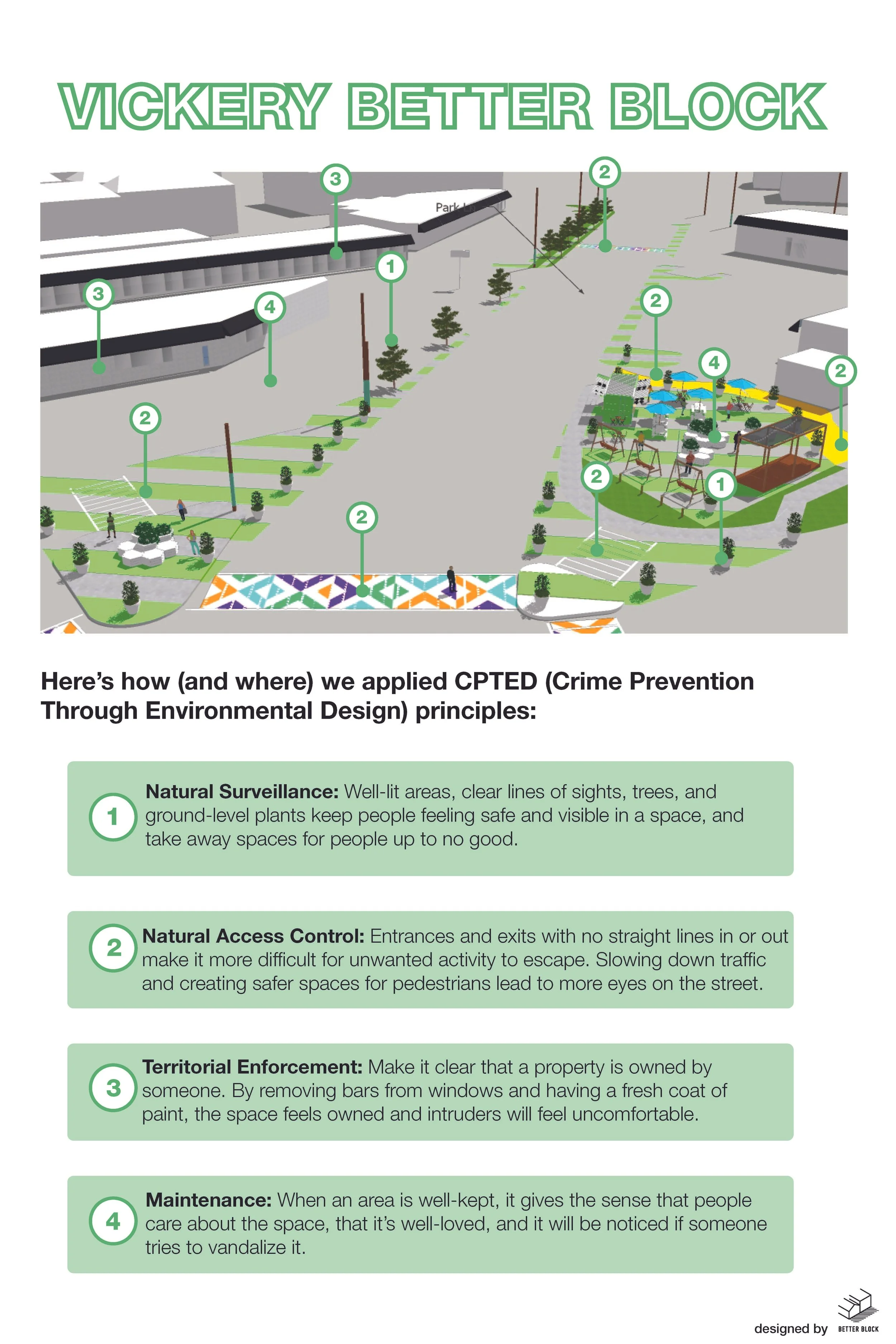
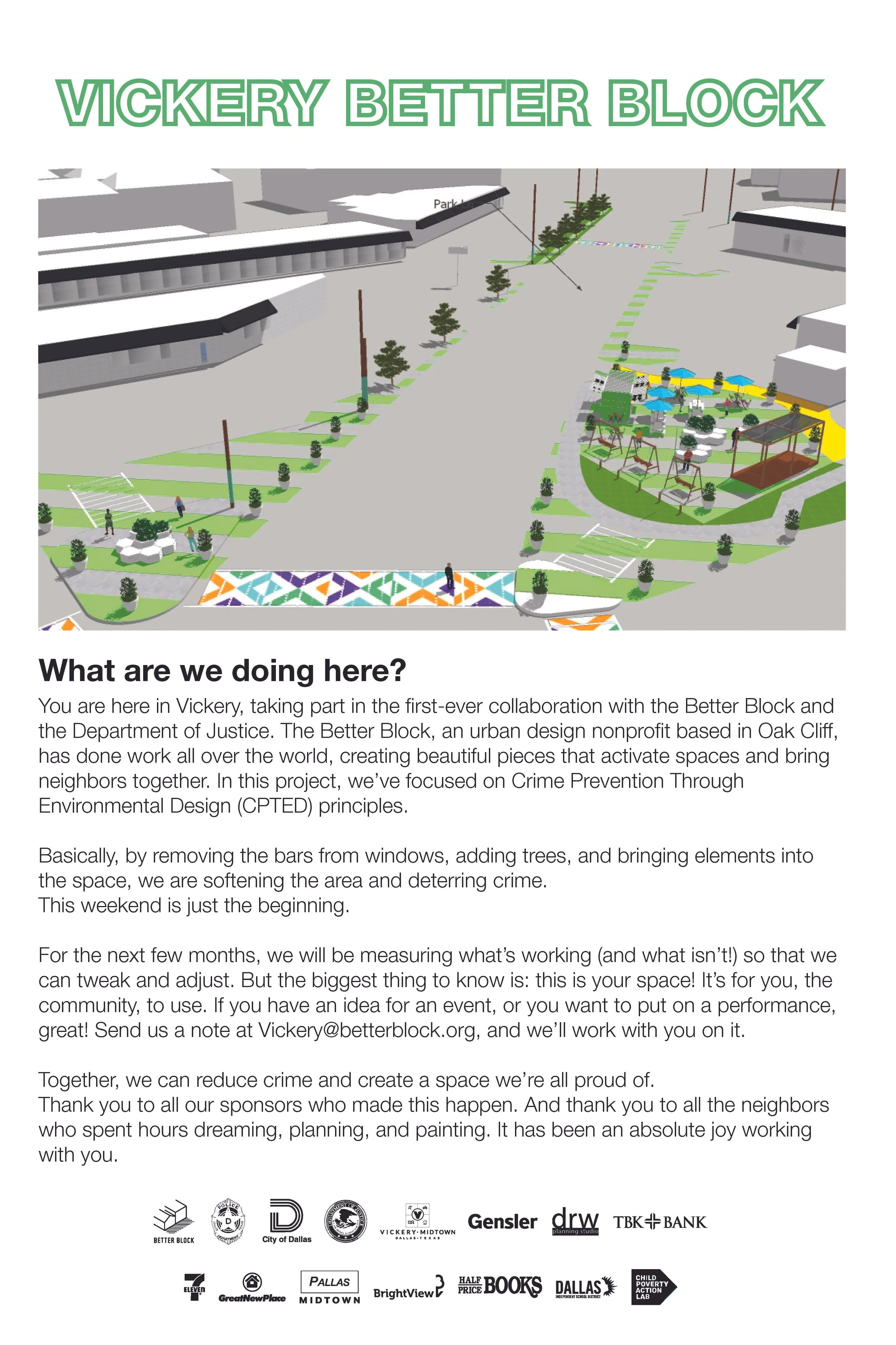
The Department of Justice reached out to the Better Block Foundation to work on making the neighborhood of Vickery Meadow safer after multiple murders had occurred on one of Dallas’ highest crime blocks through principles of Crime Prevention Through Environmental Design (CPTED).
The Background:
The DoJ wanted a solution that would make a big difference in a short amount of time and had $114,000 in grants to complete the transformation. The DoJ had already selected a block area that would undergo the transformation - a place where there was a five street intersection, a school at one of the corners, multiple businesses in the other corners, and lots of empty parking lots. The neighborhood itself is one of Dallas’ most diverse neighborhoods, and there are over 190 languages spoken in the immediate area.
Links to Articles:
https://www.betterblock.org/post/fighting-crime-with-design
https://www.betterblock.org/our-work?pgid=kq8376gn-vickery-better-block_1
Vickery Meadow
The Plan:
I was assigned as the Project Manager for this project which was a huge and important undertaking. To make this successful, we immediately coordinated with local businesses, community leaders, and the school that was directly adjacent to the site. The grant allowed us to buy materials and program the site for up to a year, so we were also reaching out to residents in the area to see if they had interest in hosting an event or market. I coordinated the material pricing, program for the opening event, and the volunteers.
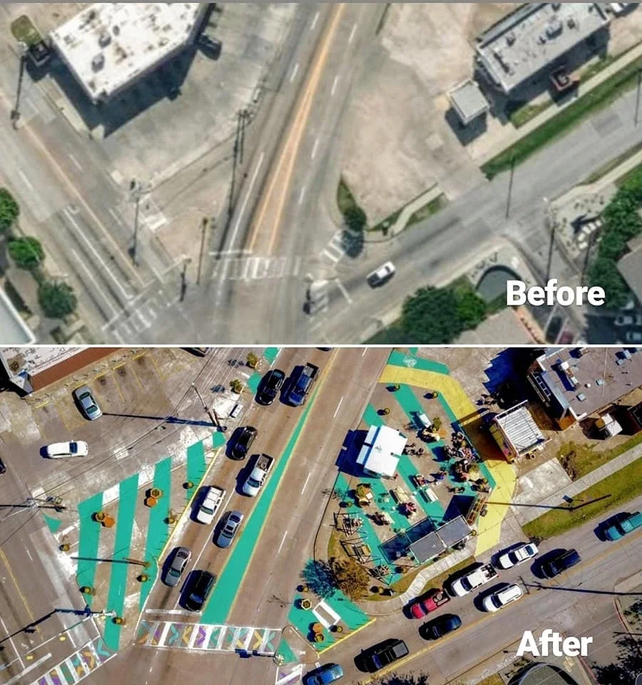
To make the space feel safer, we put fresh coats of paint on three businesses and their awnings around the intersection. We painted a mural on a blank wall facing the school. We put up swings, tables, chairs, planters, a stage, a pergola, and a shipping container that doubled as a free, pop-up bookstore with books donated by Half Price Books and storage pavilion for future events. All of this work was completed by the Better Block team, and numerous volunteers. Volunteers also helped plant, build, and set up the block for days prior to opening which is what ultimately made the project so successful. We also had students from the school come out and help us paint the intersection fun colors to make the crosswalks more visible and lively. This project leaned into its community to make the area feel enjoyable and safer for its residents and the students walking to and from school every day.
The Brief:
West Allis mayor hired the Better Block foundation to revitalize the Burnham Pointe district.
The Background:
The Burnham Pointe area needed some love and attention to inspire its community and excite the neighborhood residents to frequent the area more.
Links to Articles:
https://www.betterblock.org/post/better-block-announces-a-new-project-in-west-allis
https://www.betterblock.org/our-work?pgid=kq8376gn-west-allis-better-block_8
West Allis
The Plan:
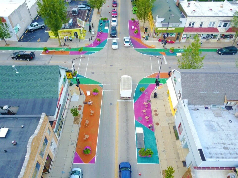
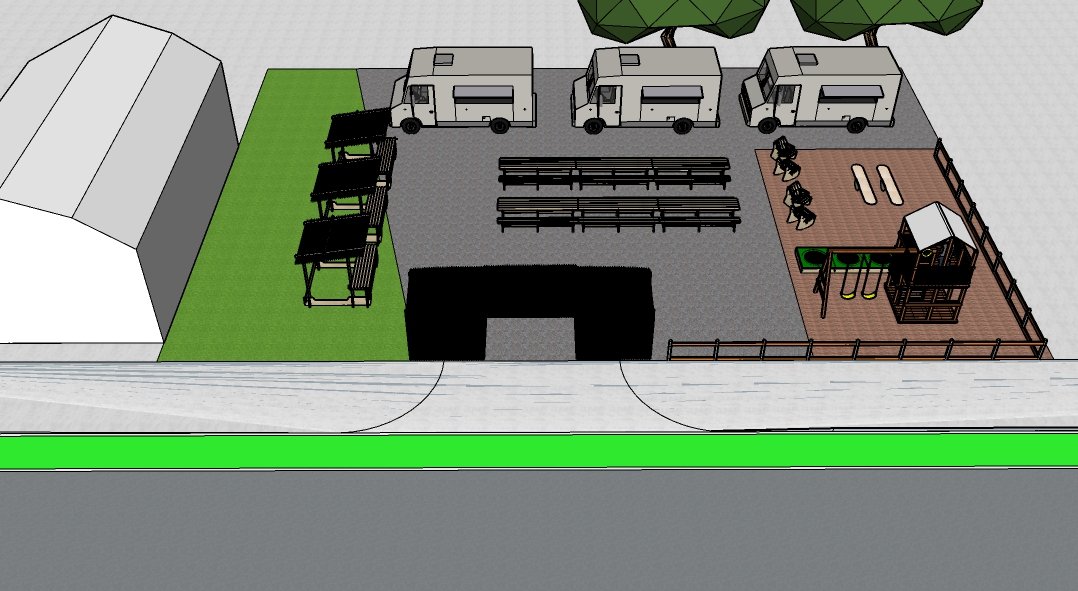
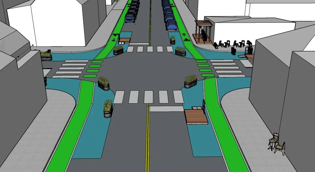
As the Project Manager for this project, the first step was to survey the community to better understand what they cared about and what they wanted to see in their neighborhood. The main topic of concern was safety regarding the high traffic speeds around the main intersection. With that information, we began to redesign the intersection with local business input as well. We proposed bump-outs at the intersection to slow traffic, raised bus stops, and implemented a bike lane on both sides of the street. Additionally, we added string lights, benches, and planters to liven the streetscape. Lastly, for our kickoff event, we programmed an empty city owned lot with a playground created by a local business, musicians, entertainment, and food trucks to create an environment that neighbors would want to visit.
The Brief:
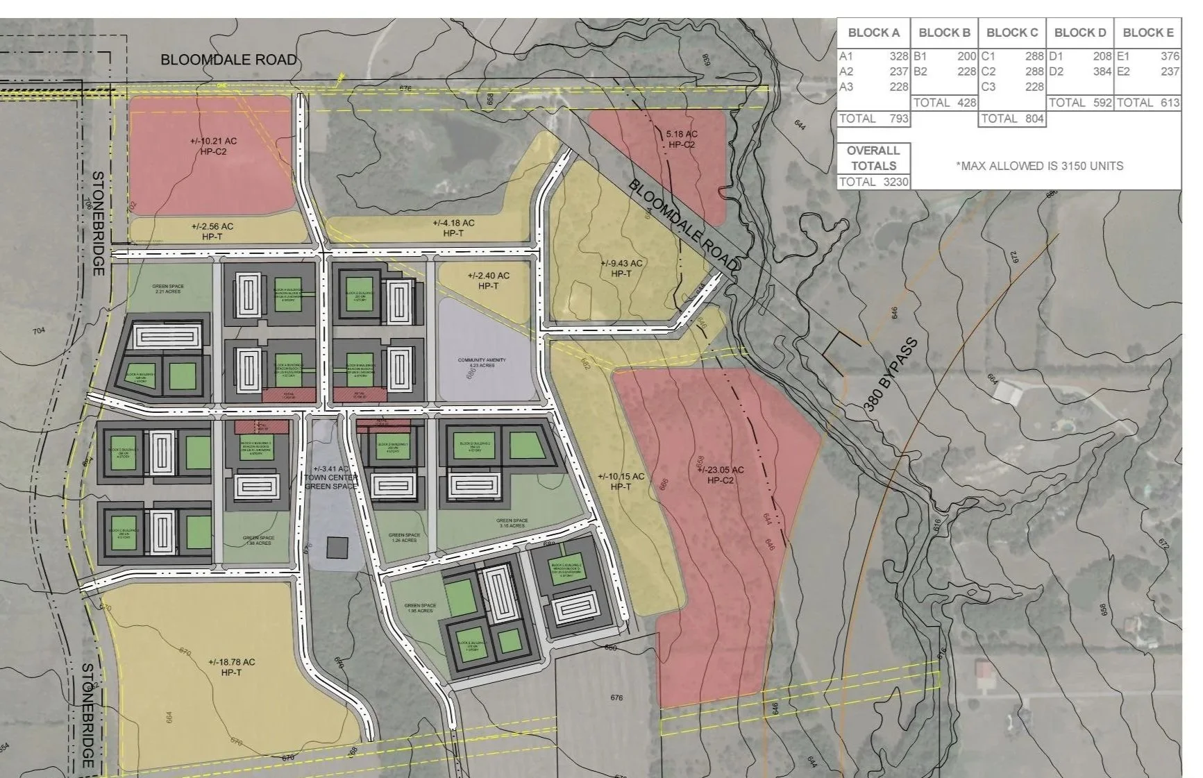
The client asked HLR to create a master plan that shows retail at the northwest and southwest corners, keep green space in the middle of the site, research zoning information, find and label easements, set up block dimensions, set up right-of-ways, and calculate unit counts in the multi-family dedicated blocks.
The Background:
This site had a previous master plan that needed to be totally revised to the clients needs. The zoning research also uncovered multiple areas that needed to be designated as green space, determined density maxes, and use types.
huntington park
The Plan:
Knowing that we had to keep retail uses in the northeast and northwest corners, I planned large blocks that accommodates multiple types of multifamily and lots of room for retail. We also chose to push the retail up against the major streets to buffer the multifamily blocks behind. After the retail blocks is a series of townhomes that have been spaced so that they have an alley that backs up to the retail. Next comes the series of multi-family wrap blocks. The goal of the entry street going north/south was to have it be framed by the retail, townhomes, and then 4 multi-family that terminated on a town center green space. The four corners of the multi-family buildings that surround the town center, have retail on the ground floor to activate the space.
The Brief:
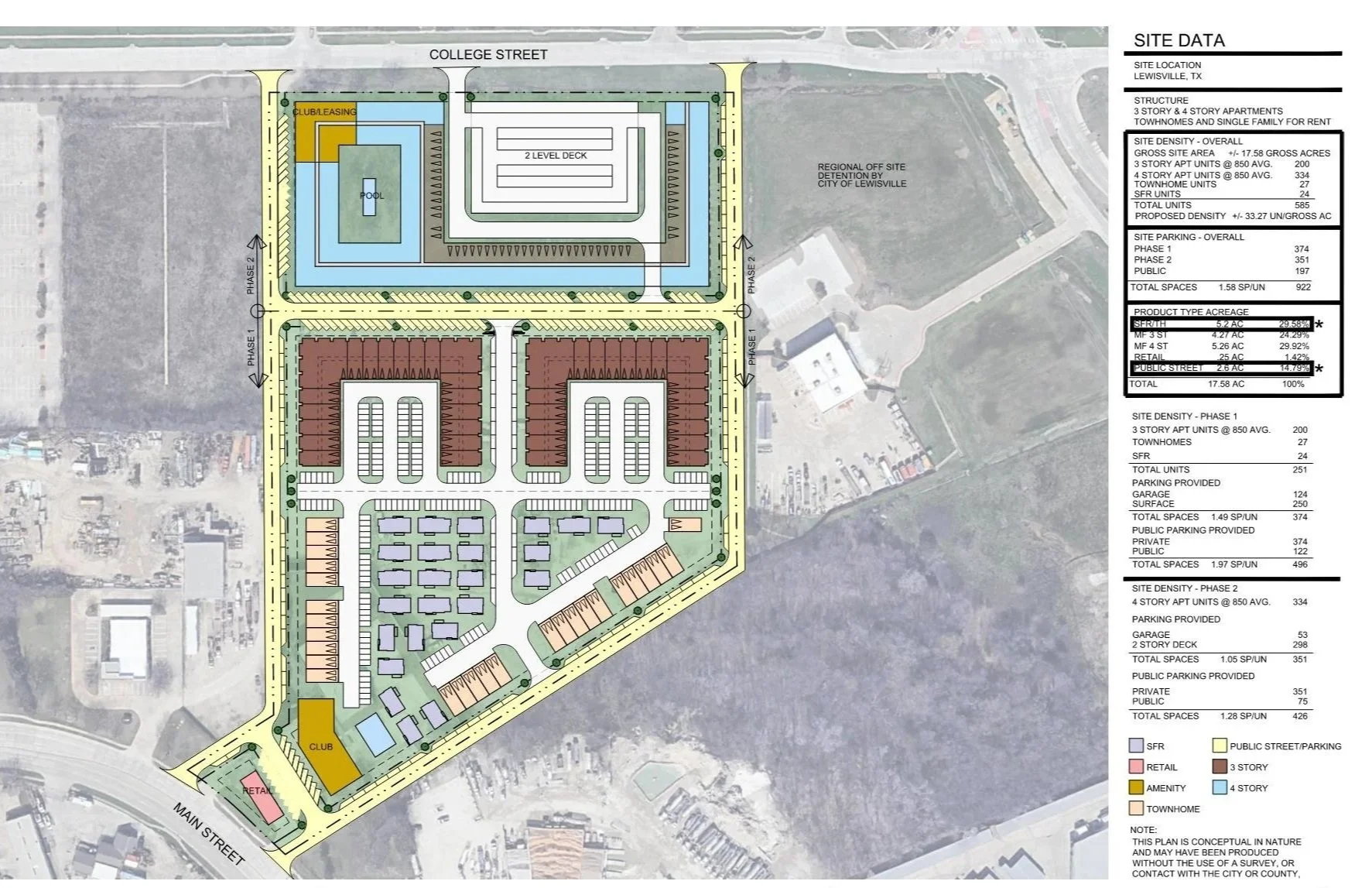
The client asked us to get 600 units on the 17.1 acre property in two phases. The units need to be split up into multiple product types with the goal being 30ish single family cottage homes, 30ish 3-story townhomes, 150ish units in 3-story multi-family buildings, and 400+ units in 4-story multi-family buildings. They also requested that the amenities be spread out between the two phases, and to provide a small spark or retail along main street.
The Background:
The client had already been working with the city on zoning and expectations of the site, so not much new info was needed. The site required us to use public streets around the perimeter of the property and to connect through the middle so we had to use the city’s their street sections and right-of-ways for any public streets built on the property.
The Standard
The Plan:
We organized a myriad of individual components of this project into a comprehensive plan. We started first with the perimeter public streets to discern the amount of space we had left over after all of the right-of-ways and setbacks were located. Then we took the most efficient portion of the site, the north half, and placed our largest buildings there. The 4-story multi-family building was placed along the street to line the street and create a nice streetscape. Then the 3-story multifamily buildings were on the other side of the public street with tuck under garages on the first floor and units above. We maintained a more urban street type going through the 3-story multifamily buildings and through the single family rentals to connect to the other public street at the south edge of the site. We lined the rest of the public streets with townhomes and placed the single family rentals internal to the site in a uniform placement. The amenities were placed at the north and south ends of the site so that residents can easily access them.
The Brief:
The client asked us to maximize density on the site with a wrap, while also staying out of the heritage and protected trees as much as possible.
The Background:
This site is located in Austin, TX. Austin has a very strict tree mitigation requirement and a strict classification for heritage trees and protected trees. Heritage trees are ones that are a certain tree type and over a certain trunk size, and protected trees are trees over a certain trunk size.
Tillery Street
The Plan:
The entrance to this site was set based on shared access between our site and the site to the north. From there, we wanted to line the public and internal street with units, and push the garage to the back side of the site where it faces the railroad tracks to help buffer the noise. The drive that goes around the garage was necessary for hose lay to get to all points of the building. The leasing was pushed off the public street a bit so potential residents could have easier access to the parking garage.
The Brief:
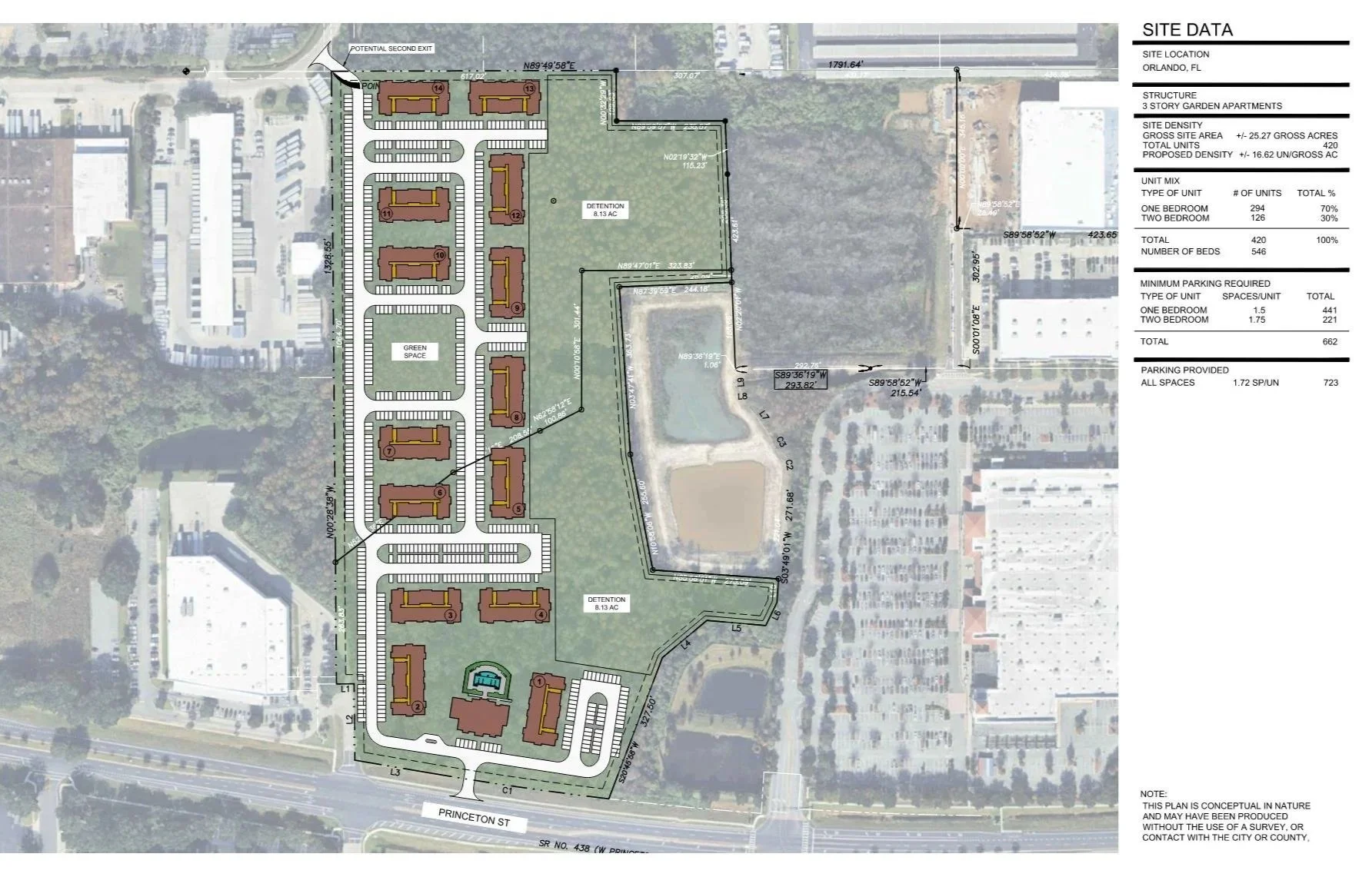
The client asked for a site plan with 3-story multifamily buildings on the 25 acre site. A civil engineer recommended that 30% of the site needs to be set aside for retention in the low point.
The Background:
This client had already developed 3-story garden multifamily buildings with us, so we were able to use the prototypes to layout the site with their desired unit mix and count.
Princeton Street
The Plan:
This site had only one public street frontage so we put our club at the frontage and all of the units behind. Looking at the development surrounding our site, none of the other buildings were located up at the street, so we kept our buildings internal to the site. One of the main goals of this site was to get views on the pool courtyard, views on the detention, and courtyards between buildings, all of which were accomplished and parked at the city’s high requirement. The detention took up a large portion of the site, which forced a more vertical layout. We were also aware that with the club at one end of the site, the buildings to the north had farther access to the amenities. We placed a central green space that could be programmed as a dog park, sport court, playground, or something else to provide better access to more amenities. Due to the amount of units on the site, we also had to figure out a second exit option for fire. We proposed a connection at the very northwest of the site.
More studies are available upon request.
Please note that all identifying details regarding clients have been removed for confidentiality.